Planning a trip to Iceland? Whether you’re a geology nerd, a thrill-seeker, or just someone who loves dramatic landscapes, the volcanoes in Iceland are an unmissable part of the experience. The land is alive with geothermal energy—hot springs, explosive craters, lava fields, and glaciers hiding fiery mountains below. In this guide, we’ve put together the ultimate list of the top 15 volcanoes in Iceland, grouped by region, expanded with local stories, eruption history, and practical travel tips. Whether you’re interested in active volcanoes in Iceland, hiking to crater rims, or just want a unique photo opportunity, this guide is your starting point.
Reykjanes Peninsula Volcanoes: Lava and Steam Near Reykjavík
Reykjanes Volcanic System (incl. Fagradalsfjall)

Location: Near Grindavík, southwest Iceland
Last Eruption: 2025

The Reykjanes Peninsula has been lighting up headlines since 2021 when Fagradalsfjall burst to life after centuries of silence. This was no ordinary eruption—it marked the beginning of a new volcanic cycle in the region, signalling that this part of Iceland was waking up again after an 800-year nap. Fagradalsfjall’s eruption was a slow, steady lava flow that built new land rather than blasting ash skyward. Because of its relatively calm behaviour and proximity to the capital, it quickly became one of the most popular eruption sites in Icelandic history.
What’s fascinating is that this system includes several volcanic centres like Krýsuvík and Svartsengi. The recent eruptions have shifted public awareness of how geologically active this area is. Each new event brings not just lava, but insight into Iceland’s tectonic movements.
Travel Tip: The eruption site is easily accessible by car from Reykjavík. Trails vary depending on current conditions, so always check vedur.is or safetravel.is before heading out.
Hengill

Location: Near Þingvellir and Reykjavík
Last Eruption: ~2,000 years ago

Hengill doesn’t spew lava anymore, but it bubbles and steams in its own quiet way. This large volcanic area sits right on the tectonic boundary where the North American and Eurasian plates are pulling apart. That makes it an ideal place for geothermal activity—and indeed, Hengill helps power much of the capital through two major geothermal stations.
Hikers are drawn here by the otherworldly trails winding past sulphur vents, hot springs, and dramatic ridges. In Icelandic sagas, the area was seen as a mysterious and dangerous place where the earth itself seemed alive. Today, it’s one of the most accessible volcanic hiking areas near the capital.
Don’t Miss: Reykjadalur hot spring river—a unique opportunity to bathe in naturally heated water as it winds through a scenic mountain valley.
South Iceland
Hekla

📍 Near Hella | ⏱ Last erupted: 2000
Hekla is one of Iceland’s most famous volcanoes—and also one of the most unpredictable. Thanks to its fiery outbursts and medieval imagination, it was feared as the “Gateway to Hell ” for centuries. It’s erupted more than 20 times since 874, often with little warning.
From a distance, it looks like a modest ridge, but it hides a volatile personality. Scientists monitor it closely, as it’s considered overdue for another eruption.
Travel tip: You can hike near Hekla, but access to the summit is limited due to safety concerns. The surrounding area offers great views and is less visited than the south coast’s big names.
Katla

📍 Beneath Mýrdalsjökull glacier | ⏱ Last major eruption: 1918
Katla is a beast. It’s hidden under the Mýrdalsjökull ice cap and is capable of massive eruptions that melt glacial ice, causing sudden and violent floods (jökulhlaups). Its last big event was in 1918, but there have been rumblings and small activity since.
Locals take Katla seriously—when Eyjafjallajökull erupted in 2010, many feared Katla would follow. It didn’t, but geologists say it’s only a matter of time.
If you visit: The town of Vík sits in Katla’s shadow. There’s a Katla visitor centre that’s worth checking out for its displays on volcanoes, glaciers, and local survival stories.
Eyjafjallajökull

📍 Between Hekla and Katla | ⏱ Last eruption: 2010
Hard to say, harder to forget. Eyjafjallajökull’s 2010 eruption is infamous for shutting down air traffic across Europe. The eruption itself wasn’t enormous, but its ash plume went straight into flight paths and stayed there for weeks.
Beneath its glacier, the volcano is still active. You can drive past it on the Ring Road or hike trails near Þórsmörk to see the impact of the eruption. Locals have turned the event into a source of pride—and plenty of merchandise.
Try This Instead: Hike the Fimmvörðuháls trail between Skógar and Þórsmörk, which passes between Eyjafjallajökull and Mýrdalsjökull. You’ll see new lava fields created by the 2010 eruption along the way.
Tindfjallajökull

📍 Inland from the south coast | ⏱ Dormant
Tindfjallajökull flies under the radar. It’s a glacier-covered stratovolcano near Hekla and Eyjafjallajökull. While it hasn’t erupted in modern times, it’s geologically significant and helps shape the landscape of south-central Iceland.
This area is rugged and less trafficked, ideal if you’re looking to step off the tourist trail and experience raw Icelandic nature.
Hiking nearby: The surrounding valleys offer secluded hikes with river crossings and mountain views.
Southeast Iceland
Öræfajökull

📍 Vatnajökull region | ⏱ Last erupted: 1727
Towering above the southeast coast, Öræfajökull is Iceland’s highest mountain, and it’s also an active volcano. Its history includes some of Iceland’s deadliest eruptions, like the massive event in 1362 that destroyed farms and left the region uninhabitable for decades.
The volcano is now dormant but closely monitored. If you’re driving the south coast, you’ll see it rising dramatically behind Skaftafell and the surrounding national park.
Adventure option: Take a glacier hike or ice climbing tour on the Vatnajökull ice cap.
Grímsvötn
📍 Under Vatnajökull glacier | ⏱ Last eruption: 2011
Grímsvötn is Iceland’s most active volcano, erupting every 5 to 10 years on average. It’s hidden beneath the thick ice of Vatnajökull, so its eruptions often involve both fire and meltwater, producing explosive ash clouds and floods.
Although it’s in a remote part of the country, it plays a huge role in Iceland’s volcanic story and is under constant scientific watch.
Not visitor-friendly, but fascinating if you’re into volcano science. Satellite and seismic monitoring from afar is how most people follow Grímsvötn.
Þórðarhyrna
📍 Also beneath Vatnajökull | ⏱ Last eruption: 1904
Less famous than its neighbour Grímsvötn, Þórðarhyrna is another glacier-covered volcano that’s still active. It’s part of a network of volcanoes under Vatnajökull that sometimes erupt together. It’s not accessible to visitors but is part of the bigger geological story of southeast Iceland.
Lakagígar (Laki)

📍 Central highlands, near Kirkjubæjarklaustur | ⏱ Last eruption: 1783–84
Laki isn’t just a volcano—it’s a volcanic event. When it erupted in the late 18th century, it sent lava across vast areas of southern Iceland, released toxic gas, caused famine, and even influenced global climate.
You can still visit the massive chain of craters today. It’s surreal, almost alien, and well worth the journey if you have a 4×4 and a love for off-the-grid landscapes.
Driving tip: Only accessible in summer via F-roads. Check conditions carefully and travel prepared.
Central Highlands
Askja

📍 Dyngjufjöll mountains | ⏱ Last major eruption: 1875
Askja is remote, otherworldly, and unforgettable. Its 1875 eruption was one of the largest in Iceland’s history, and today its crater is filled with a deep lake—Öskjuvatn—that’s often partly frozen even in summer.
Getting here is an adventure: it requires a full day trip or more via rough highland roads, but the payoff is huge. You’ll feel like you’ve landed on another planet.
Bonus experience: A short walk from the lake takes you to Víti, a smaller crater with milky geothermal water. Some brave the (cold) dip.
Herðubreið

📍 Near Askja | ⏱ Dormant
Nicknamed the “Queen of Icelandic Mountains,” Herðubreið is a perfectly shaped tuya—a flat-topped volcano formed under a glacier. It hasn’t erupted in recent history, but it stands proudly over the highlands.
It’s a challenging hike, but even seeing it from the Ring Road is memorable. In Icelandic culture, it’s a symbol of endurance and stark beauty.
Torfajökull

📍 Near Landmannalaugar | ⏱ Last eruption: 1477
This rhyolite-dominated volcano sits in one of the most visually stunning places in the country. The Landmannalaugar area is all steam vents, rainbow mountains, and natural hot springs.
Torfajökull itself is a complex system, and its geothermal energy keeps the ground alive with colours and heat.
Perfect for: Hikers and photographers. This is one of Iceland’s top trekking areas.
North Iceland
Krafla
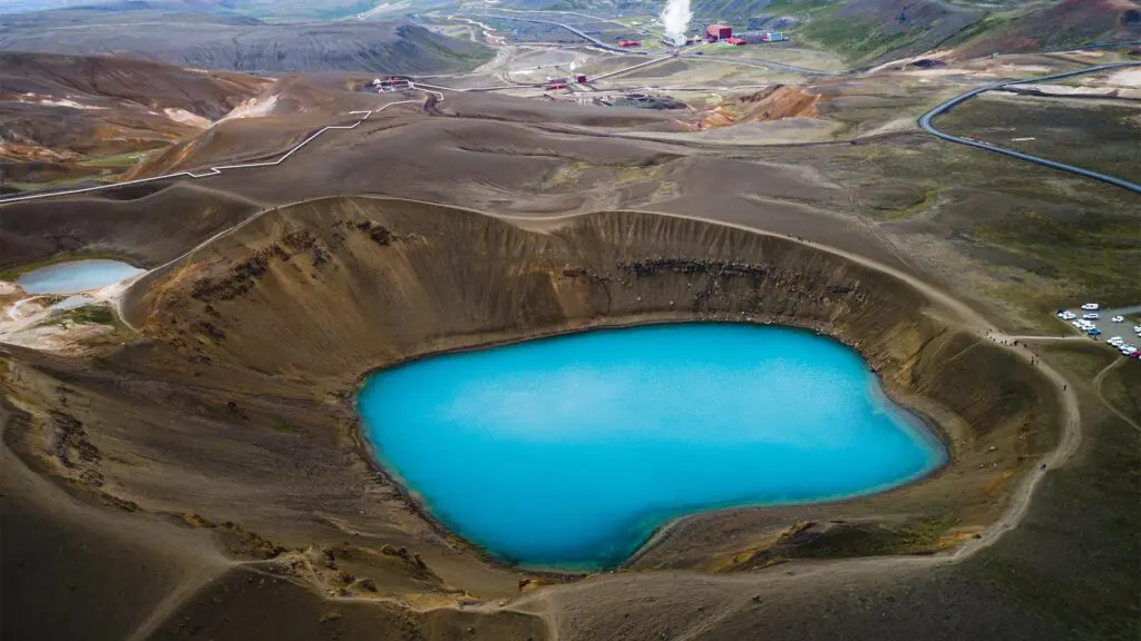
📍 Near Lake Mývatn | ⏱ Last eruption: 1984
Krafla is one of Iceland’s most accessible active volcanoes. The area experienced nearly a decade of eruptions in the 1970s and ‘80s, known as the Krafla Fires. Today, the landscape is still raw—lava fields, steaming vents, sulphur springs.
It’s also home to a geothermal power station and offers a great combination of geology and travel-friendly facilities.
Nearby sights: Mývatn Nature Baths, Hverir geothermal area, and the crater lake Víti (yes, another one!).
Why Iceland’s Volcanoes Are Worth the Trip
Iceland isn’t just a destination for scenic drives and waterfalls—it’s one of the most volcanically active places on Earth, and its volcanoes tell a story of destruction, creation, and survival. Whether you hike to the edge of a still-smoking crater, soak in a hot spring powered by underground heat, or just admire the view from a safe distance, the experience is unforgettable.
From famous names like Hekla and Katla to emerging destinations like Fagradalsfjall, visiting volcanoes in Iceland offers a rare glimpse into how this island is constantly being reshaped. These natural giants are not just geological features—they’re part of Iceland’s identity.
Whether you’re chasing lava flows, exploring geothermal valleys, or looking for the best volcano hikes in Iceland, there’s something here for every kind of traveller.
Need help planning your route? Let us know and we’ll help you create a custom itinerary with volcanoes, hot springs, and other geothermal wonders tailored to your trip.